Throughout the tour I absolutely fell in love with Ireland. The people are friendly, and the landscape seems untouched. I was reminded of vacations up north in Wisconsin by the little effect people appear to have on the land. Nothing was outlandish or overdone. People live as they need to and nothing more. Even in the most populated areas, cattle and sheep outnumber humans.
We stopped in many locations for pictures, in Doolin for lunch at Gus O'Conner's Pub in Fisher Street (there are two villages contained in Doolin; Fisher Street is one of them), and finally we headed to the Cliffs of Moher. It was beautiful. Look at the pictures and see for yourself. Each one has a caption explaining what is in the picture and a bit of information I learned.

-Leamenagh Castle-
This was are first stop on the tour. It once was an O'Brien stronghold. The O'Brien's was a dominate clan in the County Clare (where our entire trip took place). It is now on private property and surrounded by a electrical fence. See the cows?

-Burren National Park-
"Leave only your footprints, take only your memories"

-Limestone Pavement-
Naturally occurring limestone formations that are particular to Burren National Park. They are formed by glaciers during the iceages.

-Out Through the Entrance to Caherconnell Stone-
Caherconnell is a ring fort built and occupied between 900 and 1000AD by the Davoren family. It is still owned by Davoren family ancestors. This ring fort, named for its circular shape, is one of the oldest and the best preserved ring forts in Burren and in Ireland as a whole.

-Inside Caherconnell-
Here I am standing on a wall that separtated the ring fort into two sections, perhaps one for inhabitants and one for livestock. In times of distress or war, the livestock would be brought into the fort for safe keeping since the number of cattle owned signified wealth.

-Crumbled Wall of Caherconnell-
Over time the wall of the fort has collapsed and a beautiful elderberry bush has grown next to the heap of rock. The bush is proof that the collapse of the wall occurred quite a while ago.
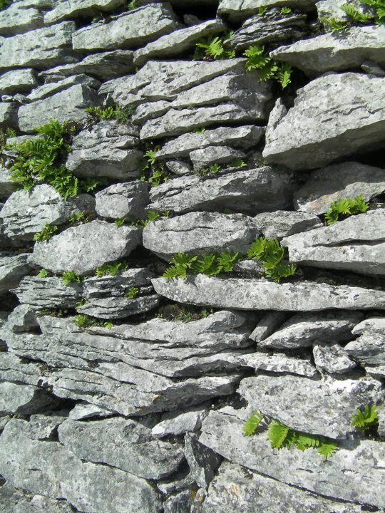
-Ancient Irish Wall-
Walls like this traced through the Clare county landscape in fences, houses, ruins, and tombs. Stone walls were used because they allowed the wind to pass through the gaps between the rocks.

- Pounlabrone: "Hollow of the Millstone"-
Remains of some 30 bodies were found in this tomb. Most of them were cremated.

-Limestone Pavement in the Ballyvaughan Valley-
The landscape here is known as a karst landscape. It looks like the surface of the moon to me.

-Blackhead-
Not much was said about blackhead, but it looks over the beautiful Galway Bay. Perhaps it was named for the black rock that coated the shore in this area. You can see one of the three Aron Islands in the distance.

-Fanor Church-
This is the ruins of the ancient Fanor Church. Burial ceremonies are still held in the cemetery for locals. There's a more recent headstone in the lower right hand corner.

-Ballyreen Shoreline-
This was the tour guides favorite spot. We could climb out to the edge. It scared Elaine to pieces. Elaine acts as mommy for the AIFS students while we are here. Hi Elaine!

-The Cliffs of Moher-
These cliffs are absolutely breath taking and some 300 meters high. It was a hike up for sure.
I bought my hat in Doolin from a Sweater Shop.

-Cliffs of Moher-
Looking south down the coastline and toward the Atlantic.

-Cliffs of Moher-
Beautiful even without me.

-Cliffs of Moher-
Looking out toward the North. The public attraction area ended approx. 500 meters from the location where this picture was taken on private property. I did not venture beyond the safety point but peolpe often do. I found this pic online and included it for it's beauty.

-Cliffs of Moher-
This picture was taken by a peer at the safety point. You can tell the image above is of the same rock formation at the bottom of the cliff.

-Friends at the Cliffs of Moher-
These are other AIFS students. A couple of them are housemates of mine*.
From left: Andy*, Me, Morgan*, Charlie, Kri, and Lorren
Leamenagh Castle, Burren National Park, Limestone Pavement, Carren Church, Caherconnell Stone Fort, Poulnabrone, Ballyvaughan Valley, Gleninagh Castle, Galway Bay, Blackhead, Aran Islands, Fanor and Fanor beach, Balleyreen, Ballinnalacken Castle, Doolin, Cliffs of Moher, Ennistimon, Inagh
Pictures borrowed from Lorren Roots and Charlie Johnsons and some online source I cannot seem to find.
Thanks guys!
No comments:
Post a Comment